




VOR ILS GPS

Descrizione di VOR ILS GPS
This application is NOT CERTIFIED to be used FOR FLIGHT GUIDANCE.
Use only in Visual Meteorological Conditions.
Do not use as single source of guidance.
The developer is not responsible for damage resulting from incorrect usage of this application.
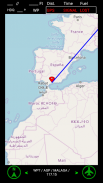
- You must define a reference point: VOR, ADF, NDB, or the touchdown point of a runway.
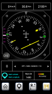
- The Horizontal Situation Indicator will provide indications to this point.
- The green arrow indicates the heading to the reference point.
- If the reference point is the touchdown point in a runway, the HSI will provide also indications to fly a 3º glideslope to that point (simulating an ILS approach).
- Choose the course you want to follow. The Course Deviation Indicator will diplay a deviation up to 10º each side of the selected course.
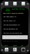
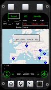
- The reference point must be defined introducing its coordinates and gps altitude. You can introduce up to 20 waypoints.
- You can save the coordinates of your current position by pressing the Mark button and importing them as a new waypoint.
Example:
N 40º 22' 12.92"
W 003º 46' 36.4"
Connect the location sensor of your device.
The information provided during the first two minutes (mainly the altitude data) will not be reliable.
Warning: Some devices do not provide gps data when in battery low mode.
Questa applicazione non è certificato per essere utilizzato PER IL VOLO DI ORIENTAMENTO.
Utilizzare solo in Visual Condizioni meteorologiche.
Non usare come unica fonte di orientamento.
Lo sviluppatore non è responsabile per i danni derivanti da un utilizzo errato di questa applicazione.
- È necessario definire un punto di riferimento: VOR, ADF, NDB, o il punto di atterraggio di una pista.
- L'indicatore di situazione orizzontale fornirà indicazioni per questo punto.
- La freccia verde indica il titolo al punto di riferimento.
- Se il punto di riferimento è il punto di atterraggio in una pista, l'HSI fornirà anche indicazioni di volare un sentiero di discesa 3º a quel punto (la simulazione di un avvicinamento ILS).
- Scegli il corso che si desidera seguire. L'indicatore di deviazione della rotta sarà diplay una tolleranza fino a 10º ciascun lato del percorso selezionato.
- Il punto di riferimento deve essere definito introducendo sue coordinate GPS e altitudine. È possibile introdurre fino a 20 waypoint.
- È possibile salvare le coordinate della vostra posizione corrente premendo il pulsante Marco e importandoli come un nuovo waypoint.
Esempio:
N 40º 22' 12.92"
W 003º 46' 36,4"
Collegare il sensore posizione del dispositivo.
Le informazioni fornite durante i primi due minuti (principalmente i dati di altitudine), non sarà affidabile.
Attenzione: alcuni dispositivi non forniscono i dati GPS in modalità batteria scarica.


